Our Gallery is Open | Please Contact Us To Schedule Your Visit.

Antique Map of Northeast England: Antique Map: Eboracum, Lincolnia, Derbia, Staffordia, Notinghamia by Henricus Hondius 1642
Antique Map of Northeast England: Antique Map: Eboracum, Lincolnia, Derbia, Staffordia, Notinghamia by Henricus Hondius 1642 | VERSO
Load image into Gallery viewer, Antique Map of Northeast England: Antique Map: Eboracum, Lincolnia, Derbia, Staffordia, Notinghamia by Henricus Hondius 1642
Load image into Gallery viewer, Antique Map of Northeast England: Antique Map: Eboracum, Lincolnia, Derbia, Staffordia, Notinghamia by Henricus Hondius 1642 | VERSO

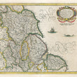
1642 Eboracum, Lincolnia, Derbia, Staffordia, Notinghamia...

Regular price SOLD

Unit price per 

By: Henricus Hondius

Date: 1642 (published) Amsterdam

Dimensions: 14 x 16.5 inches (35.5 x 42 cm)

An elegant map of northeast England by Henricus Hondius, published out of Amsterdam during the golden age of Dutch map making in 1642. The map presents the English counties of  Yorkshire,  Derbyshire, Rutland,  Staffordshire, Norfolk, Leicestershire, Lincolnshire, and Nottinghamshire, noting all of the villages within. A lovely title cartouche embellishes the top right corner while a sailing ship and large whale roam the Germanic Ocean. 

Condition: Map is in A condition, issued folded now mostly flat with minor separations along the outer folds that have been repaired on the verso. None of these separations enter the map image.

Inventory #12550

1200 W. 35th Street #425 Chicago, IL 60609 | P: (312) 496 - 3622

Close (esc)

Join Our Newsletter

Interested in maps, prints, and upcoming related events? Sign up for our newsletter for fresh NWC inventory and announcements.

Age verification

By clicking enter you are verifying that you are old enough to consume alcohol.

Search

Shopping Cart

Your cart is currently empty.
Shop now